Submitting Tasking Orders
The process of submitting a tasking order can be broken into optionally two steps, but minimally one required step.
- Discovery (Optional): Get greater visibility into upcoming opportunities of where Albedo's satellites can collect imagery
- Submission: Place a tasking order using your custom parameters or the results of the above Discovery step
Discover Tasking Opportunities
If you'd like visibility into upcoming tasking opportunities, you can query for accesses for a given area of interst by using the /access endpoint. For a given area of interest or "AOI" (and optionally, a satellite ID), a list of upcoming accesses to that AOI will be returned, along with some attributes of those accesses. These accesses reflect our simulated satellite's position and location at a given time, and satisfy geometric constraints and site conditions (i.e. illumination) for image collection.
Example WKT Access AOI
POINT (115.80463505863878 -31.919861689290812)
POLYGON((106.6420132281068 10.837676298843478,106.65823522822888 10.837676298843478,106.65823522822888 10.82250195089807,106.6420132281068 10.82250195089807,106.6420132281068 10.837676298843478))
POINT (-82.37197682138252 23.108775389758886)
POINT (-93.6164359191181 41.58913674173535)
POLYGON((12.518359773225004 41.90193978505458,12.521353118485624 41.90193978505458,12.521353118485624 41.90056628939917,12.518359773225004 41.90056628939917,12.518359773225004 41.90193978505458))
Submitting a Tasking Order
This API gives you the ability to directly task and interact with Albedo's satellites.
To keep a very complex process simple, you must minimally provide Albedo with an area of interest or "AOI". Our API allows for optional, additional constraints to be provided as well - see the full parameter list inTasking Specification.
Once you've identified your tasking constraints, the order can be placed via the API. Our internal systems will evaluate whether the task you've submitted can be collected and will return an associated acceptance or rejection.
Area of Interest (AOI)
The geographical area describing where on Earth they would like Albedo to collect imagery, commonly referred to as an AOI. The area of interest must be:
- Specified as a WKT or GeoJSON string - you can create your own WKT AOI here and your own GeoJSON AOI here(! Coordinates must be specified as EPSG:4326
- A simple polygon or a point geometry type
When a point is provided, Albedo will attempt to collect a 1km x 1km circle, where the point is the center of the circle.
When a polygon is provided, it must not exceed 50 sq. km of total area.
Example GeoJSON AOIs
Feel free to use any of these example AOIs to submit as tasking order:
{
    "type": "Polygon",
    "coordinates": [
        [
            [ -105.10, 39.93 ],
            [ -105.07, 39.93 ],
            [ -105.07, 39.91 ],
            [ -105.10, 39.91 ],
            [ -105.10, 39.93 ]
        ]
    ]
}
{
    "type": "Polygon",
    "coordinates": [
        [
            [ -73.95727847458876, 40.808477818070891 ],
            [ -74.00568698288954, 40.744781474488235 ],
            [ -73.98285601975478, 40.732945429802200 ],
            [ -73.93393252732314, 40.799252131565702 ],
            [ -73.95727847458876, 40.808477818070891 ]
        ]
    ]
}
{ "type": "Point", "coordinates": [-74.0151647663104, 40.700946879890516] }
{
    "type": "Polygon",
    "coordinates": [
        [
            [ -0.16055172637819304, 51.510363776234080 ],
            [ -0.11282986358522429, 51.510363776234080 ],
            [ -0.11282986358522429, 51.490701449998056 ],
            [ -0.16055172637819304, 51.490701449998056 ],
            [ -0.16055172637819304, 51.510363776234080 ]
        ]
    ]
}
{ "type": "Point", "coordinates": [2.2944804884269265, 48.85874411612496] }
{
    "type": "Polygon",
    "coordinates": [
        [
            [ 139.69376067354008, 35.66251390791891 ],
            [ 139.70779399110600, 35.66251390791891 ],
            [ 139.70779399110600, 35.65358740041513 ],
            [ 139.69376067354008, 35.65358740041513 ],
            [ 139.69376067354008, 35.66251390791891 ]
        ]
    ]
}
Example WKT AOIs
POLYGON((-105.10 39.93,-105.07 39.93,-105.07 39.91,-105.10 39.91,-105.10 39.93))
POLYGON((-73.95727847458876 40.80847781807089,-74.00568698288954 40.744781474488235,-73.98285601975478 40.7329454298022,-73.93393252732314 40.7992521315657,-73.95727847458876 40.80847781807089))
POINT(-74.0151647663104 40.700946879890516)
POLYGON((-0.16055172637819304 51.51036377623408,-0.11282986358522429 51.51036377623408,-0.11282986358522429 51.490701449998056,-0.16055172637819304 51.490701449998056,-0.16055172637819304 51.51036377623408))
POINT(2.2944804884269265 48.85874411612496)
POLYGON((139.69376067354008 35.66251390791891,139.707793991106 35.66251390791891,139.707793991106 35.65358740041513,139.69376067354008 35.65358740041513,139.69376067354008 35.66251390791891))
Tasking Specification
These parameters can be used to provide optional constraints that will be used to constraint a collection opportunity.
Min and Max Acquisition Dates
The user can provide a date/time range for which to constrain collection attempts for the AOI. The minimum allows acquisition date is the current time, and the max acquisition date is the current time plus 7 days - basically, users can schedule 1 week out.
"min_acquisition_date_time": "2023-01-21T00:00:00.000+00:00",
"max_acquisition_date_time": "2023-01-28T00:00:00.000+00:00"
If no constraints are specified, the following defaults are used:
| Constraint | Default |
|---|---|
| min_acquisition_date_time | current time |
| max_acquisition_date_time | current time + 7 days |
Note: We use the dateutillibrary, so are able to support most datetime formats. We recommend using ISO-8601/W3C.
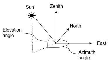
Min and Max Sun Angles
min_sun_azimuth_angle, max_sun_azimuth_angle, min_sun_elevation_angle, max_sun_elevation_angle
The user can provide constraints on how the sun is illuminating the target at the time of acquisition. This includes both sun azimuth and sun elevation angles.
If no constraints are specified, the following defaults are used:
| Constraint | Default Degrees |
|---|---|
| start_sun_azimuth_angle | 0° |
| stop_sun_azimuth_angle | 360° |
| min_sun_elevation_angle | -5° |
| max_sun_elevation_angle | 90° |
Satellite Angles
start_sat_azimuth_angle, stop_sat_azimuth_angle, min_sat_elevation_angle, max_sat_elevation_angle
Similar to the sun angle constraints above, the user can provide constraints around the satellite angle relative to the target at time of collection.
| Constraint | Default Degrees |
|---|---|
| start_sat_azimuth_angle | 0° |
| stop_sat_azimuth_angle | 360° |
| min_sat_elevation_angle | 0° |
| max_sat_elevation_angle | 90° |
Off Nadir Angle
The user can also constrain how far off-nadir they would like to image during the collection.
We currently only support 30 degrees off nadir, but plan to support 60 degrees off nadir at launch.
Updated 10 months ago
Once you successfully submitted a tasking order, learn how to check your order's latest status!