Data Formats
Each asset produced by Albedo's processing systems is processed into an industry standard format. All of our assets can be downloaded, but we strive to also supply assets in formats that can be streamed directly through our Data Access API in order to support high-performance user workloads and to take the burden of data management off of our users when possible. The formats we support are described below and we try to offer assets in formats that make sense for the ways we envision our users working with those assets. For example, view ready assets are offered in cloud-optimized geotiff and web map tile formats.
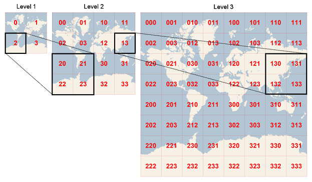
Web Map Tiles
In the early 2000's Google revolutionized internet mapping with the invention of slippy-maps. With slippy-maps came web map tiles. Over the years several competing standards have developed for web map tiles. Albedo currently supports two of the most common web map tile standards, XYZ and WMTS. All of the web map tile flavors share similar characteristics.
Web map tile systems divide the world up into increasingly detailed pre-defined cells. Starting with the coarsest level (level 0), which covers the entire world at very low resolution. As the zoom level increases, each cell from the previous level is divided into 4 cells. So, if level 0 contains one cell, level 1 contains 4 cells, level 2 contains 16 cells, and so on.
Many web and desktop mapping software applications and libraries support web map tiles including:
- Openlayers
- Leaflet (incl. Folium)
- QGIS
- ArcMap
These applications can connect directly to Albedo's data access API to allow users to view Albedo imagery assets. For more information on web map tiles see:
Cloud Optimized GeoTiff
Cloud-optimized geotiffs (COGs) are geotiff files that are internally laid out in such a way that they can be randomly accessed over a network. Internally, the image is tiled and stored at multiple resolutions, creating a pyramid-like structure similar to web map tiles. Clients can interact with a cloud-optimized geotiff over network protocols like HTTPS. This allows for streaming interaction where the client never has to download the entire image at once.
Many image software applications and libraries support COGs including:
- Geospatial Data Abstraction Library (GDAL)
For more information see:
Cloud Optimized Tiff
Not all remote sensing images are compatible with the geotiff format. In particular, raw images that haven't been geo-rectified aren't compatible with the geotiff format. For this reason, Albedo uses a tiff file layout that's similar to a COG, but doesn't include the geospatial header elements of a geotiff. These images can be accessed randomly/streamed over a network like COG.
Internal & Not Currently Supported Formats
Albedo Format
Internally, Albedo uses a custom image format that is conducive to very high performance and highly scalable reads and writes across networks. We call this format the Albedo image format. The format combines some of the best characteristics of COG (pyramids, arbitrary tile size and grid) and some of the best characteristics of web map tiles (small tiles spread across multiple files). Additionally, the format supports high-performance lossless compression schemes. The format is simple to work with and doesn't require specialized libraries like more complex formats like COG. We typically don't expose our public assets in Albedo format, but it's worth mentioning since is part of our high-performance image processing architecture and is one of the enablers of our industry leading low latency processing.
National Imagery Transmission Format 2.1 (NITF)
NITF is an image file format used heavily by the US government. NITF images don't support streaming over a network, so NITF assets must be downloaded in their entirety.
Non-Image Formats
In addition to imagery assets, Albedo produces metadata assets to assist users in working with imagery assets. Non-imagery formats are generally in JSON format except when users require specific industry standard metadata formats.
Updated 4 months ago